The Tide-Line Is Not a Permanent Boundary
The tide-line is not a permanent boundary. Learn what shore marks can reveal about water, weather and local conditions, and where their limits lie.
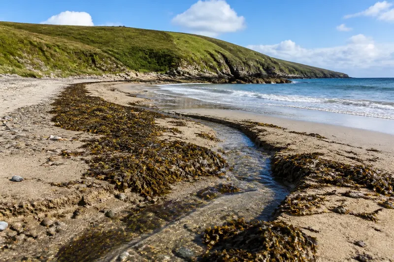
At the end of a beach walk, you notice a strip of kelp caught against the foot of a dune fence. It marks where material was carried, but it cannot tell you by itself how high the sea stood or when it arrived. A tide-line is a record with gaps: its meaning depends on the process that left it and the ground that preserved it.
That distinction matters because a visible trace can look more precise than it is. The sea leaves signs of water levels, wave action and weather, but those signs overlap and change. Read them as evidence of coastal processes, not as a single, dependable boundary.
Lines with different origins
People use “tide-line” for several things: a band of stranded seaweed, a change in colour or moisture, or the point where waves reach during a particular visit. These marks are related, but they are not interchangeable. The astronomical tide describes the regular rise and fall of sea level; waves and local weather affect how water reaches the shore.
A forecast high tide is a prediction for a place and time, not a promise that every visible trace will stop at the same point. Wind can push water towards a coast, while waves climb beyond the quieter water level. Shore shape also matters: a shallow foreshore and a steep beach show the same change in water level differently.
“High-water mark” can also mean a line defined for a formal purpose. A strand of debris is not a survey boundary. If a line matters for ownership, access or regulation, consult the relevant local authority or a qualified professional.
What marks can tell you
Each kind of trace offers a different clue. A fresh deposit of shells or seaweed suggests that floating material was carried onto the shore. Scoured ground may indicate that moving water disturbed the surface. A shallow pool shows where water is retained by a hollow or barrier. None, on its own, identifies the exact height or timing of the water that made it.
The lifespan of a mark varies. A wave can rearrange loose debris, while a sheltered corner may preserve it longer. Rain and freshwater flow can cut through deposits or add new sediment. What appears to be one continuous line may therefore combine traces from different episodes.
Look at the setting before interpreting a mark. A rock ledge can trap water; a low gap in shingle can direct waves inland; a stream can carry material across the beach. Two nearby patches may preserve different evidence of the same conditions.
Weather and local shape
Wind direction influences the water surface and the waves. A wind blowing towards shore may push water landward; one blowing offshore can have a different local effect. The outcome depends on the coastline’s orientation and form, so a sheltered bay may respond unlike an exposed headland nearby.
Atmospheric pressure also affects sea level, alongside the astronomical tide. Rainfall and river flow can alter currents and leave their own marks, particularly near an estuary. After rough weather, fresh debris may be conspicuous, but its position does not reveal the water level by itself.
Consider an invented situation: you arrive at a sheltered bay after a windy night. Kelp lies above a band of damp ground, and a small stream has cut a channel through the deposit. You note the current water edge separately, then compare the kelp with the channel and beach slope. The reasonable reading is that waves carried the kelp inland, the stream later interrupted its line, and the water edge records only the present moment; the exact highest level remains unknown.
A careful field record
If you want to compare shore conditions on later visits, record observations rather than assigning a firm boundary. A phone photograph can show the general arrangement, while a notebook can capture details that an image misses.
- Current water edge: Check where water meets the shore and whether waves run higher; if wave run-up is visible, describe the edge as changing, otherwise note that it reflects the present water only.
- Debris deposits: Check whether kelp, shells or driftwood form a ridge or scattered patches; if the deposit is continuous, record its shape without calling it a boundary, otherwise note where it breaks.
- Surface disturbance: Check for scouring or newly moved material; if the surface is disturbed, describe the affected area, otherwise do not infer recent wave action from debris alone.
- Water pathways: Check for streams, runnels and channels; if one crosses a deposit, note that it may have altered the line, otherwise keep water movement as an unconfirmed possibility.
- Shore form: Check whether the spot is steep, shallow, sheltered or exposed; if the ground changes nearby, compare observations by location, otherwise avoid assuming the same trace has the same meaning along the whole beach.
- Weather context: Check wind direction, rain and recent rough conditions if known; if these are known, include them as context, otherwise mark them as unknown rather than guessing.
Keep the record modest: “kelp ridge above a stream channel” is more useful than “the high-tide boundary”. Note where you stood and what the water was doing. On a return visit, compare the arrangement of clues rather than expecting an old mark to remain intact.
Questions about tide-lines?
Is a wrack line the high-tide mark?
Not necessarily. Waves can carry seaweed and other debris beyond the quieter high-water edge, and later water can move it again. Treat it as evidence of material transport, not a precise record of tide level.
Why can one beach show several lines?
Different episodes may leave separate deposits, while later waves or streams partly erase them. Changes in slope and small channels can also divide or redirect traces over a short distance.
Can damp ground show how far the sea reached?
It can suggest recent wetting, but shade, seepage and rain may also keep ground damp. Compare it with the surrounding terrain and other signs before attributing it to the tide.
Does a predicted tide explain every shore mark?
No. The prediction describes expected sea level, while wind, waves, pressure and local shore shape influence what reaches the land. A visible deposit may also outlast the conditions that put it there.
Use the right kind of evidence
The tide-line is not a permanent boundary because visible traces record different processes and persist for different lengths of time. A wrack ridge can help explain where floating material was deposited; a channel may show where water travelled; neither should be treated as a precise limit of the sea.
When you next see a clear-looking line, look beyond it for signs that qualify the first impression: a broken deposit, a stream crossing it or a change in the shore’s slope. The most useful observation may be the one that tells you what the line cannot establish.